
Last week we demonstrated how Gemini 3.8 Flash's visual reasoning is sufficiently advanced that it can visually describe an entire television news broadcast from a 1/4fps thumbnail grid with sufficient detail that it can be used with keyword search for advanced visual search of a broadcast. In that example we extracted one frame every 4 seconds from a television news broadcast, reduced them to thumbnail size and combined them into a thumbnail grid 6 across and with as many rows as needed to represent the entire broadcast. Here we repeat this process, but this time we ask Gemini 3.8 Flash to search for identifiable geographic locations and compile them into a list, performing "visual geocoding". While not perfect, the results below are deeply impressive, showing Gemini able to visually understand the input image as a montage of independent very low resolution thumbnail images and identify a number of locations, suggesting that with higher resolution and finer-grained images, it could likely precisely geocode a video in the same way as an investigative journalist. No data was used to train or tune any model and Gemini was provided only the two low-resolution thumbnail grids below and did not have any access to the broadcast itself.
You are an expert visual geospatial analyst.
Attached is a thumbnail grid of a video.
Go through it extremely carefully and identify any locations you can identify (specific landmarks, buildings, mountains, landscapes, waterways, cities, etc). Be exhaustive. Give me a bulleted list of each location you identify and the specific rows in the thumbnail grid in which it appears.
Explain why you believe that location is depicted.
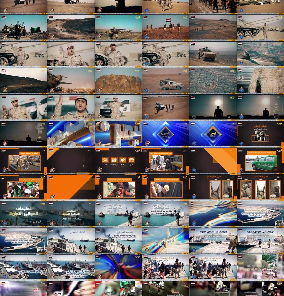
Let's start with this broadcast from Yemen earlier today (click to see the full res version):

Here are the locations Gemini visually identified from the thumbnail grid:
- Throne of Bilqis / Temple of Baran (Arsh Bilqis), Marib (Coordinates: 15.4033° N, 45.3431° E): Appearing in Row 6 from the bottom (second thumbnail from the left), this site is identified by the distinctive row of monolithic stone pillars rising from the desert floor, representing the ancient Sabaean sanctuary where five of the original six limestone pillars remain standing in their unmistakable historical formation.
- Dar al-Hajar (Rock Palace), Wadi Dhahr (Coordinates: 15.4408° N, 44.1269° E): Appearing in Row 6 from the bottom (fourth thumbnail from the left), this location is identified by the iconic five-story palace built in the 1930s by Imam Yahya, perched directly atop a towering natural rock spire and adorned with traditional white-gypsum decorative window friezes (qamariyah).
- Socotra Island / Dixam Plateau & Firmihin Forest (Coordinates: 12.5030° N, 53.9930° E): Appearing in Row 5 from the bottom (third thumbnail from the left), this landscape is distinguished by an open mountain plateau dotted with dense stands of Dragon's Blood Trees (Dracaena cinnabari), an endemic, umbrella-canopied species unique to the Socotra Archipelago.
- Old City of Sana'a (Coordinates: 15.3556° N, 44.2139° E): Appearing in Row 6 and Row 5 from the bottom (first thumbnail on the far left in both rows), this site is recognized by its dense urban skyline of multi-story burnt-brick and dark basalt tower-houses richly decorated with geometric white-gypsum relief patterns and minarets, characteristic of the UNESCO World Heritage city.
- Yemeni Terraced Highlands / Haraz Mountains (Coordinates: 15.0667° N, 43.7500° E): Appearing in Row 6 from the bottom (third thumbnail from the left) and Row 5 from the bottom (fifth thumbnail from the left), these locations are identified by the dramatic, verdant agricultural terraces stepped into steep, mist-prone mountain slopes, typical of the western highlands in the Haraz and Ibb regions.
- Marib Desert & Frontlines / Sirwah Axis (Coordinates: 15.4600° N, 45.3200° E): Appearing throughout the middle rows (notably Rows 19 to 25 and Rows 28 to 36 from the top), this terrain is identified by extensive military field reports and broadcast banners explicitly referencing Marib (مأرب), showcasing the arid desert plains, earthen berms, and rocky desert ridges typical of the outskirts of Marib and the Sirwah frontline.
How about this broadcast from Afghanistan earlier today (click for full res)?

Gemini's geographic assessment:
- Masjid al-Haram & The Kaaba (Mecca, Saudi Arabia) [Coordinates: 21.4225° N, 39.8262° E] — Appears in Rows 3, 59, 63, and 64. Row 3 (columns 1–4) features an overhead aerial perspective and ground-level view displaying the central Kaaba draped in the black Kiswa, encircled by pilgrims performing Tawaf across the polished marble Mataf courtyard, enclosed by the multi-tiered colonnades and minarets of the Grand Mosque. Row 59 (columns 4–6) presents an extreme high-angle panoramic aerial shot peering directly down into the mosque courtyard and Kaaba enclosure from the adjacent clock tower. Row 63 (column 5) and Row 64 (column 1) show nighttime views of the illuminated concentric prayer rings formed by worshippers circling the Kaaba across the expansive courtyard.
- Al-Masjid an-Nabawi / The Prophet’s Mosque (Medina, Saudi Arabia) [Coordinates: 24.4672° N, 39.6108° E] — Appears in Row 5 (columns 3–6). Distinctly depicts the world-famous Green Dome (Gumbad-e Khizra) erected over the tomb of the Prophet Muhammad, alongside tall white-and-gold minarets and the surrounding outdoor marble courtyards fitted with the signature giant convertible Teflon umbrella shade canopies.
- Abdul Rahman Mosque (Grand Mosque of Kabul) & Kabul City Basin (Kabul, Afghanistan) [Coordinates: 34.5173° N, 69.1764° E] — Appears in Rows 3, 4, 5, 6, 7, 8, 9, and 10. Exterior views in Row 3 (columns 5–6), Row 4 (columns 1–2), Row 5 (column 2), Row 6 (columns 5–6), and Row 7 (columns 1–6) showcase the terracotta/red multi-domed Haji Abdul Rahman Mosque near Zarnegar Park and the Kabul River with its two soaring minarets, backed by Kabul's characteristic urban sprawl climbing the slopes of Koh-e Asamayi (TV Hill) and Koh-e Sher Darwaza. Interior views across Row 4 (columns 3–4), Row 6 (columns 1–4), Row 8 (columns 1–4), Row 9 (columns 1–4), and Row 10 (columns 1–2) detail the main prayer hall, highlighting its ornate tiered chandeliers, arched mezzanine galleries, patterned carpets, and circular Islamic calligraphy medallions.
- The Arg (Presidential Palace Compound / Dilkusha Palace) (Kabul, Afghanistan) [Coordinates: 34.5244° N, 69.1768° E] — Appears in Rows 21, 22, 23, 24, 25, and 26. Depicts official Taliban diplomatic protocol, beginning in Rows 21–22 with armed honor guards stationed in front of the historic stone entry gates and colonnaded porticos of Dilkusha Palace / Char Chinar Palace within the Arg compound. Rows 23–25 document arriving motorcades of black executive sedans and foreign diplomatic delegations walking the tree-lined paved palace avenues and interior hallways. Row 26 captures a bilateral meeting salon inside the palace compound with Turkish and Taliban delegations seated beneath both the national flag of Turkey and the white flag of the Islamic Emirate of Afghanistan.
- Kabul Urban Center & Roundabouts (Kabul, Afghanistan) [Coordinates: 34.5285° N, 69.1815° E] — Appears in Rows 28, 29, 30, 31, and 32. Showcases streetscapes and urban infrastructure across downtown Kabul, including commercial high-rises in Shahr-e Naw, the major traffic intersections around Massoud Square / Zanbaq Square roundabout lined with tall white Islamic Emirate flags (Row 29, column 4 and Row 30, columns 1–2), and the exterior facades, courtyards, and parking areas of administrative complexes such as the Kabul Municipality (Kabul Shahrawali) headquarters (Rows 30–32).
- Grand Assembly / National Ulama Conference Hall (Loya Jirga Hall) (Kabul, Afghanistan) [Coordinates: 34.5218° N, 69.1091° E] — Appears in Rows 44, 45, 46, 47, 48, 49, and 50. Shows a massive national assembly of hundreds of turbaned Taliban officials, ministers, and Islamic scholars (ulama) gathered in tiered auditorium seating at the grand national convention hall (Loya Jirga Hall / Kabul University convention grounds), complete with elevated podiums, official microphones, and backdrops bearing circular Quranic calligraphy seals.
- Abraj Al-Bait Complex & Makkah Royal Clock Tower (Mecca, Saudi Arabia) [Coordinates: 21.4187° N, 39.8262° E] — Appears in Rows 59, 60, 61, 62, 63, and 64. A dedicated architectural documentary feature focusing on the Makkah Royal Clock Tower, highlighting sunset silhouette views against vibrant orange skies (Row 59 [columns 1–3], Row 64 [columns 2–4]), neighboring high-rise towers of the Jabal Omar and Abraj Al-Bait complexes (Rows 60–61), close-ups of the 43-meter green-illuminated clock faces reading "Allahu Akbar" beneath the top crescent and spire with laser projections (Row 62 [columns 2–4], Row 63 [column 3], Row 64 [columns 5–6]), and interior mechanical rooms from the Clock Tower Museum revealing the giant Swiss-engineered drive gears, weights, and motor drives (Row 62 [columns 5–6], Row 63 [column 1]).